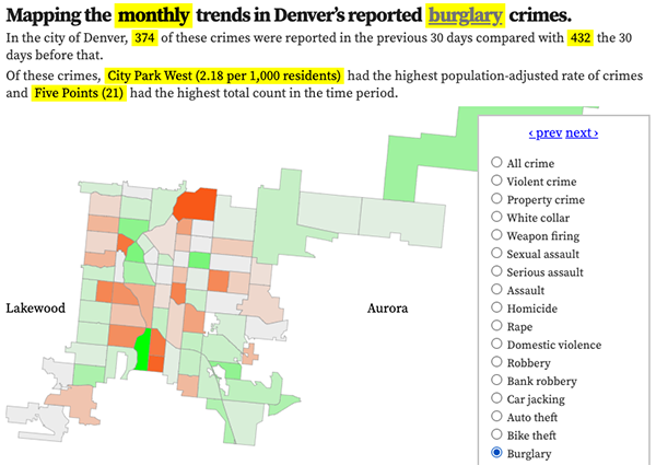
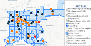
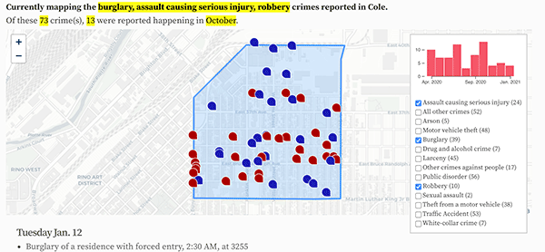
Denver neighborhood map, white-collar crimes, 2024
Reported white-collar crimes. Hover over or tap a neighborhood for details.
Denver white-collar crime statistics
Monthly reported white-collar crimes in Denver
White-collar crime crimes, by time of day
What time reported white-collar crimes happen in Denver.
White-collar crime crimes, by weekday
The day of the week reported white-collar crimes happen.
New: Sign up for weekly email updates.
Denver white-collar crimes in the news
- Denver man indicted on federal fraud charges in $8.5 million vacation rental scam on Airbnb, Vrbo
- Published January 5
- Disbarred Denver attorney Steve Bachar sentenced to 3 years in prison in theft, fraud case
- Published November 6, 2023
- Disbarred Denver attorney Steve Bachar to plead guilty again after judge rejected first deal. He now faces up to 6 years in prison.
- Published September 15, 2023
- The $174,000 question: Who gets the money Steve Bachar brought to court?
- Published April 3, 2023
New: Recent crime ranking changes in white-collar crime
There were 17 notable ranking changes in these crime categories when comparing the rankings four weeks ago to the current rankings. This list updates Mondays. The lower the rank the worse the reported crime.
- College View / South Platte fell 44 ranks, from 62nd to 18th.
- Cole fell 17 ranks, from 28th to 11th.
- East Colfax fell 15 ranks, from 25th to 10th.
- Overland fell 19 ranks, from 42nd to 23rd.
- Indian Creek fell 17 ranks, from 45th to 28th.
- Washington Virginia Vale fell 15 ranks, from 49th to 34th.
- Five Points fell 9 ranks, from 23rd to 14th.
- Baker fell 8 ranks, from 20th to 12th.
- Berkeley fell 7 ranks, from 34th to 27th.
- Hampden South improved 6 ranks, from 24th to 30th.
- Whittier fell 11 ranks, from 57th to 46th.
- Kennedy fell 5 ranks, from 27th to 22nd.
- Belcaro fell 4 ranks, from 13th to 9th.
- Washington Park West fell 12 ranks, from 63rd to 51st.
- Virginia Village improved 4 ranks, from 12th to 16th.
- Northeast Park Hill improved 4 ranks, from 17th to 21st.
- Highland fell 7 ranks, from 52nd to 45th.
Featured: The best and worst neighborhoods for white-collar crimes.
White-collar crime rate, Denver, 2024
- DIA: 16.25 per 1,000 residents (20 incidents total)
- CBD: 1.73 (7)
- Civic Center: 1.7 (3)
- Union Station: 1.38 (7)
- North Capitol Hill: 1.35 (8)
- City Park West: 1.31 (6)
- Central Park: 1.25 (22)
- Auraria: 1.21 (1)
- Belcaro: 1.06 (5)
- East Colfax: 0.89 (10)
- Cole: 0.87 (4)
- Baker: 0.86 (5)
- University Hills: 0.84 (5)
- Five Points: 0.74 (11)
- Clayton: 0.71 (3)
- Virginia Village: 0.71 (10)
- Cheesman Park: 0.7 (6)
- College View / South Platte: 0.7 (5)
- Sun Valley: 0.7 (1)
- Washington Park: 0.68 (5)
- Northeast Park Hill: 0.66 (6)
- Kennedy: 0.65 (3)
- Overland: 0.62 (2)
- Southmoor Park: 0.62 (3)
- Hale: 0.59 (4)
- Hampden: 0.58 (11)
- Berkeley: 0.58 (5)
- Indian Creek: 0.57 (2)
- West Highland: 0.54 (5)
- Hampden South: 0.54 (8)
- Valverde: 0.53 (2)
- Capitol Hill: 0.51 (8)
- Windsor: 0.51 (7)
- Washington Virginia Vale: 0.51 (7)
- Barnum West: 0.51 (3)
- Montclair: 0.51 (3)
- Cherry Creek: 0.48 (3)
- Athmar Park: 0.46 (4)
- Sloan Lake: 0.38 (3)
- Goldsmith: 0.38 (2)
- Jefferson Park: 0.35 (1)
- Speer: 0.34 (4)
- Harvey Park South: 0.34 (3)
- Fort Logan: 0.34 (3)
- Highland: 0.33 (3)
- Whittier: 0.33 (2)
- Montbello: 0.32 (11)
- Bear Valley: 0.32 (3)
- Sunnyside: 0.31 (3)
- Ruby Hill: 0.28 (3)
- Washington Park West: 0.28 (2)
- Globeville: 0.28 (1)
- Westwood: 0.24 (4)
- Harvey Park: 0.24 (3)
- Lowry Field: 0.24 (2)
- Gateway / Green Valley Ranch: 0.23 (8)
- West Colfax: 0.22 (2)
- Mar Lee: 0.22 (3)
- Hilltop: 0.22 (2)
- University: 0.21 (2)
- Cory-Merrill: 0.21 (1)
- North Park Hill: 0.19 (2)
- Lincoln Park: 0.17 (1)
- Platt Park: 0.17 (1)
- Elyria-Swansea: 0.15 (1)
- Barnum: 0.15 (1)
- University Park: 0.13 (1)
- South Park Hill: 0.11 (1)
- Marston: 0.09 (1)
White-collar crime count, Denver, 2024
- Central Park: 22 incidents
- DIA: 20
- Five Points: 11
- Hampden: 11
- Montbello: 11
- East Colfax: 10
- Virginia Village: 10
- Capitol Hill: 8
- Gateway / Green Valley Ranch: 8
- North Capitol Hill: 8
- Hampden South: 8
- Windsor: 7
- Washington Virginia Vale: 7
- Union Station: 7
- CBD: 7
- Cheesman Park: 6
- Northeast Park Hill: 6
- City Park West: 6
- Baker: 5
- West Highland: 5
- University Hills: 5
- Belcaro: 5
- Washington Park: 5
- Berkeley: 5
- College View / South Platte: 5
- Speer: 4
- Hale: 4
- Athmar Park: 4
- Westwood: 4
- Cole: 4
- Kennedy: 3
- Barnum West: 3
- Mar Lee: 3
- Highland: 3
- Cherry Creek: 3
- Clayton: 3
- Sloan Lake: 3
- Ruby Hill: 3
- Civic Center: 3
- Montclair: 3
- Harvey Park South: 3
- Harvey Park: 3
- Sunnyside: 3
- Southmoor Park: 3
- Bear Valley: 3
- Fort Logan: 3
- West Colfax: 2
- Overland: 2
- Valverde: 2
- University: 2
- Whittier: 2
- Washington Park West: 2
- North Park Hill: 2
- Indian Creek: 2
- Hilltop: 2
- Lowry Field: 2
- Goldsmith: 2
- Lincoln Park: 1
- Jefferson Park: 1
- Elyria-Swansea: 1
- University Park: 1
- Barnum: 1
- Cory-Merrill: 1
- Platt Park: 1
- South Park Hill: 1
- Globeville: 1
- Auraria: 1
- Marston: 1
- Sun Valley: 1
Recent Denver white-collar crimes
April 16
- Fraud by use of computer, at 9:20 PM, at 5195 W Byron Pl in Sloan Lake.
- Fraud by use of computer, at 8:00 AM, at 5480 N Danube St in Gateway / Green Valley Ranch.
April 15
- Fraud by use of computer, at 10:00 PM, at 7995 E Mississippi Ave in Windsor.
- Fraud by telephone, at 2:00 PM, at 4824 W Moncrieff Pl in West Highland.
- Fraud by use of computer, at 8:47 AM, at 3401 N Osage St in Highland.
- Criminal impersonation, at 6:31 AM, at 1355 N Krameria St in Montclair.
April 12
- Criminal impersonation, at 10:21 PM, at S Colorado Blvd and E Alameda Ave in Belcaro.
- Failure to return rental vehicle, at 2:35 PM, at 615 S Havana St in Windsor.
- Failure to return rental vehicle, at 2:27 PM, at 615 S Havana St in Windsor.
- Fraud by use of computer, at 1:05 PM, at 2660 W Hillside Ave in College View / South Platte.
April 11
- Counterfeiting an object, at 6:00 PM, at 2200 Market St in Five Points.
- Counterfeiting an object, at 12:58 PM, at 6395 E Hampden Ave in Hampden.
- Fraud by use of computer, at 12:00 PM, at 2100 S Clay St in College View / South Platte.
- Failure to return rental vehicle, at 10:00 AM, at 8150 E Colfax Ave in East Colfax.
- Fraud by telephone, at 9:00 AM, at 1349 S Pearl St in Platt Park.
April 10
- Fraud by telephone, at 1:30 PM, at 1700 E Louisiana Ave in Washington Park.
April 9
- Fraud by telephone, at 11:00 AM, at 333 S High St in Washington Park.
- Failure to return rental vehicle, at 8:00 AM, at 615 S Havana St in Windsor.
- Fraud by use of computer, at 12:00 AM, at 2575 S Adams St in University Park.
April 8
- Failure to return rental vehicle, at 1:43 PM, at 615 S Havana St in Windsor.
- Fraud by use of computer, at 11:55 AM, at 444 E 19th Ave in North Capitol Hill.
- Fraud by telephone, at 11:00 AM, at 2750 S Wadsworth Blvd in Bear Valley.
- Fraud by use of computer, at 8:00 AM, at 3310 W 31St Ave in West Highland.
- Criminal impersonation, at 12:00 AM, at 4005 S Roslyn St in Hampden South.
April 7
- Fraud by use of computer, at 8:00 AM, at 2380 N Xanthia Way in Central Park.
April 6
- Unauthorized use of a financial transaction device, at 8:13 PM, at 8060 E Girard Ave in Hampden.
- Fraud by telephone, at 6:32 PM, at 1700 Platte St in Highland.
- Forgery of checks, at 12:45 PM, at 1075 S Havana St in Windsor.
- Fraud by telephone, at 9:30 AM, at 3955 N Oneida St in Northeast Park Hill.
- Unauthorized use of a financial transaction device, at 2:59 AM, at 3975 N Peoria Way in Central Park.
April 5
- Failure to return rental vehicle, at 8:31 PM, at 23790 E 78th Ave in DIA.
- Police impersonation, at 6:00 PM, at the 3200 block of S Parker Rd in Kennedy.
- Fraud by use of computer, at 5:07 PM, at the 1400 block of N Quebec St in East Colfax.
- Fraud by telephone, at 3:18 PM, at 4200 N Perry St in Berkeley.
- Criminal impersonation, at 3:00 PM, at the 1500 block of N Verbena St in East Colfax.
- Criminal impersonation, at 12:00 PM, at 2931 N Race St in Whittier.
- Fraud by telephone, at 11:30 AM, at 4210 N Fraser Way in Montbello.
- Possession of counterfeiting device, at 8:15 AM, at 3770 Walnut St in Cole.
April 4
- Forgery of checks, at 6:10 PM, at 357 S Locust St in Washington Virginia Vale.
- Embezzlement by an employee, at 12:00 AM, at 4486 N Peoria St in Montbello.
April 3
- Fraud by telephone, at 12:25 PM, at 1575 N Pennsylvania St in North Capitol Hill.
- Forgery of checks, at 12:00 PM, at 1410 N Wolff St in West Colfax.
- Fraud by telephone, at 9:30 AM, at 300 S Jackson St in Belcaro.
April 2
- Fraud by use of computer, at 5:52 PM, at 1457 N Ivy St in Montclair.
- Failure to return rental vehicle, at 5:30 PM, at 3410 S Galena St in Hampden.
- Police impersonation, at 5:35 AM, at 2100 Welton St in Five Points.
April 1
- Fraud by use of computer, at 7:42 PM, at 4465 N Davenport Way in Montbello.
- Counterfeiting an object, at 5:15 PM, at 8330 E Quincy Ave in Hampden South.
March 31
- Unauthorized use of a financial transaction device, at 6:22 PM, at 8700 Pena Blvd in DIA.
- Fraud by telephone, at 4:15 PM, at 940 S Leyden St in Washington Virginia Vale.
More reported white-collar crimes in Denver, or, white-collar crimes by date.


