- 4655 N Humboldt St: 20
- 4220 N Garfield St: 18
- 3200 E 45th Ave: 18
- 2121 E 48th Ave: 17
- 4290 N Brighton Blvd: 14
- 4600 Block N Gaylord St: 14
- 3888 E 45th Ave: 13
- 3850 Wynkoop St: 12
- 4250 N Jackson St: 11
- 2100 Block E 48th Ave: 10
- E 48th Ave / N Colorado Blvd: 10
- 3705 E 42nd Ave: 9
- 4600 N Humboldt St: 9
- 4600 Block N Williams St: 9
- 4300 Block N Adams St: 9
- 3900 Block Blake St: 9
- 4001 N Colorado Blvd: 8
- 4801 N Colorado Blvd: 8
- E 47th Ave / N Gaylord St: 8
- 4799 N Colorado Blvd: 7
- 5000 Block N Milwaukee St: 7
- 3800 Wynkoop St: 7
- 4300 Block N Josephine St: 7
- 5190 N Brighton Blvd: 6
- 5160 N York St: 6
- 3901 Wynkoop St: 6
- 4650 N Steele St: 6
- E 45th Ave / N Steele St: 6
- 4210 N Jackson St: 6
- 4900 Block N Clayton St: 6
- 4200 Block N Brighton Blvd: 5
- 3680 E 52nd Ave: 5
- 4300 Block N Fillmore St: 5
- 3900 Block Wynkoop St: 5
- 4400 Block N Elizabeth St: 5
- 2101 E 48th Ave: 4
- 4075 N Colorado Blvd: 4
- 3051 E 45th Ave: 4
- 5126 N Brighton Blvd: 4
- 4400 Block N Cook St: 4
- 4809 N Race St: 4
- 4500 Block N Clayton St: 4
- 5225 N Vasquez Blvd: 4
- 4700 Block N Vine St: 4
- 2705 E 42nd Ave: 3
- 3625 E 48th Ave: 3
- N Colorado Blvd / E 48th Ave: 3
- 3900 E 45th Ave: 3
- 4900 Block N Milwaukee St: 3
- 4400 Block N Milwaukee St: 3
- 4700 Block N Williams St: 3
- 4708 N Williams St: 3
- 4000 Block N Adams St: 3
- 4690 N Brighton Blvd: 3
- 2655 E 52nd Ave: 3
- 4200 Block N Fillmore St: 3
- E 45th Ave / N Fillmore St: 3
- 4242 Wynkoop St: 3
- E 48th Ave / N Gaylord St: 3
- I70 Hwyeb / N Steele St: 3
- 4700 Block N St Paul St: 3
- 2200 Block E 47th Ave: 3
- 4100 N Jackson St: 3
- 4837 N Jackson St: 3
- 4700 Block N Race St: 3
- 3200 Block E 41st Ave: 3
- 4700 Block N Claude Ct: 3
- 4242 N Elizabeth St: 3
- 4390 N Madison St: 3
- 2600 Block E 43rd Ave: 2
- 3300 E 43rd Ave: 2
- 2501 E 48th Ave: 2
- I70 Hwywb / N Colorado Blvd: 2
- 2800 Block E 45th Ave: 2
- 4700 Block N Milwaukee St: 2
- 4347 N Milwaukee St: 2
- 5032 N Milwaukee St: 2
- 5200 N Monroe St: 2
- E 48th Ave / N Williams St: 2
- 4900 Block N Adams St: 2
- 5200 Block N Adams St: 2
- E 45th Ave / N Adams St: 2
- 2400 E 46th Ave: 2
- E 47th Ave / N Brighton Blvd: 2
- 4910 N Brighton Blvd: 2
- 3855 E 52nd Ave: 2
- 4555 N York St: 2
- 4352 N Fillmore St: 2
- 4900 Block N Fillmore St: 2
- 4500 Block N Fillmore St: 2
- 4522 N Fillmore St: 2
- 3880 Wynkoop St: 2
- 3850 Blake St: 2
- 4300 Block N Cook St: 2
- 4100 Block N Cook St: 2
- 4900 Block N Cook St: 2
- E 46th Ave / N Steele St: 2
- 4330 N Steele St: 2
- 4400 Block N St Paul St: 2
- 4812 N St Paul St: 2
- 4300 Block N St Paul St: 2
- 4500 Block N Josephine St: 2
- 4600 Block N Josephine St: 2
- 46 North / N Josephine St: 2
- E 42nd Ave / N Jackson St: 2
- 4120 N Jackson St: 2
- 4201 N Jackson St: 2
- E 48th Ave / N Jackson St: 2
- E 49th Ave / N Race St: 2
- 4600 Block N Race St: 2
- E 47th Ave / N Race St: 2
- 4600 Block N Clayton St: 2
- 4700 Block N High St: 2
- 4757 N Vasquez Blvd: 2
- 5165 N Vasquez Blvd: 2
- 4445 N Elizabeth St: 2
- 2650 E 49th Ave: 2
- 4850 Packing House Rd: 2
- 4690 N Vine St: 2
- 2577 E 40th Ave: 2
- 4600 Block N Thompson Ct: 2
- 3600 E 44th Ave: 2
- 3500 Walnut St: 2
- N Cook St / E 51st Ave: 2
- 4400 Block N Columbine St: 2
- 5355 N Harrison St: 2
Featured: Read the October 2025 Denver-city crime report.
Denver crime maps
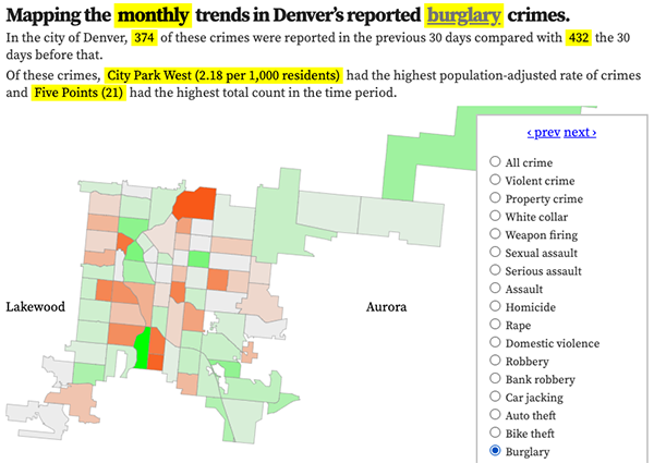
Denver crime trends map
The crimes trends map shows the change in crime counts and rates on a monthly and year-to-date basis.

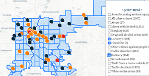
The Denver-city recent crime map
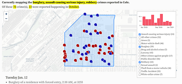
The recent crimes map shows where crimes across the city were reported in the last two or so months, and shows which addresses across the city have logged the most reported crimes.

All city crime maps
Choose from neighborhood and crime-specific crime maps.
