- 1600 California St: 152
- 500 16th St: 35
- 1543 Stout St: 31
- 800 Block 16th St: 30
- 1550 Court Pl: 28
- 1600 Block Stout St: 26
- 16th St / Champa St: 26
- 700 14th St: 25
- 1600 Block Glenarm Pl: 24
- 650 15th St: 24
- 1515 Arapahoe St: 23
- 16th St / Stout St: 22
- 1600 Glenarm Pl: 19
- 1520 Stout St: 18
- 321 17th St: 17
- 1500 Block California St: 16
- 1700 Block Champa St: 16
- 1000 Block 16th St: 16
- 101 W Colfax Ave: 16
- 800 Block 17th St: 15
- 1501 Arapahoe St: 15
- 1475 California St: 14
- 1801 California St: 14
- 16th St / California St: 13
- 16th St / Arapahoe St: 13
- 1625 N Broadway St: 13
- 16th St / Stout Champa Aly: 13
- 15th St / Champa St: 12
- 750 16th St: 12
- 934 16th St: 11
- 900 Block 16th St: 11
- 818 17th St: 11
- 16th St / Curtis St: 11
- 801 15th St: 11
- 1700 Block Stout Champa Aly: 11
- 17th St / Stout Champa Aly: 11
- 440 14th St: 10
- 1500 Block Stout St: 10
- 1600 Champa St: 10
- 1726 Champa St: 10
- 535 16th St: 10
- 1405 Curtis St: 10
- 400 15th St: 10
- 240 14th St: 9
- 1500 Champa St: 9
- 1020 15th St: 9
- 200 Block 15th St: 9
- 16th St / California Stout Aly: 9
- 1500 Block Arapahoe St: 9
- 1750 Welton St: 9
- 1420 Stout St: 8
- 17th St / Champa St: 8
- 1600 Block Champa St: 8
- 600 Block 16th St: 8
- 1776 Curtis St: 8
- 1000 Block 15th St: 8
- 1900 Block Arapahoe St: 8
- 16th St / Welton St: 8
- 303 W Colfax Ave: 8
- 1000 Block 14th St: 7
- 15th St / Stout St: 7
- 1715 Tremont Pl: 7
- 15th St / California St: 7
- 951 16th St: 7
- 700 Block 16th St: 7
- 950 17th St: 7
- 370 17th St: 7
- 15th St / California Stout Aly: 7
- 1600 Block Arapahoe St: 7
- 1955 Arapahoe St: 7
- 1101 13th St: 7
- 1540 Cleveland Pl: 7
- 201 W Colfax Ave: 7
- 800 Block 14th St: 6
- 16th St / Glenarm Pl: 6
- 1450 Glenarm Pl: 6
- 17th St / Tremont Pl: 6
- 1100 Block 16th St: 6
- 400 Block 16th St: 6
- 820 16th St: 6
- 817 17th St: 6
- 1700 Block Curtis St: 6
- 15th St / Curtis St: 6
- 675 15th St: 6
- 1800 Block Arapahoe St: 6
- 15th St / Arapahoe St: 6
- 17th St / Arapahoe St: 6
- 1801 N Broadway St: 6
- 1600 Block Stout Champa Aly: 6
- 1100 14th St: 5
- 1730 Glenarm Pl: 5
- 1600 Stout St: 5
- 18th St / Stout St: 5
- 1400 Block Tremont Pl: 5
- 14th St / California St: 5
- 14th St / Champa St: 5
- 1500 Block Champa St: 5
- 1725 Champa St: 5
- 600 16th St: 5
- 801 16th St: 5
- 707 17th St: 5
- 1881 Curtis St: 5
- 1144 15th St: 5
- 1800 Lawrence St: 5
- 15th St / Court Pl: 5
- 1515 Cleveland Pl: 5
- 15th St / Stout Champa Aly: 5
- 891 14th St: 4
- 1635 Stout St: 4
- 1531 Stout St: 4
- 1437 California St: 4
- 1820 California St: 4
- 1900 California St: 4
- 1551 Champa St: 4
- 1345 Champa St: 4
- 500 Block 16th St: 4
- 815 16th St: 4
- 900 16th St: 4
- 300 Block 16th St: 4
- 1125 17th St: 4
- 900 Block 17th St: 4
- 1475 Curtis St: 4
- 999 18th St: 4
- 1100 Block 18th St: 4
- 700 Block 15th St: 4
- 1438 Arapahoe St: 4
- N Speer Blvd / Arapahoe St: 4
- 17th St / Lawrence St: 4
- 1300 Block Lawrence St: 4
- 15th St / Lawrence St: 4
- 1400 Welton St: 4
- 1555 Court Pl: 4
- 16th St / Court Pl: 4
- 1500 Block Cleveland Pl: 4
- 15th St / Champa Curtis Aly: 4
- 1100 Block 14th St: 3
- Arapahoe St / 14th St: 3
- 1325 Glenarm Pl: 3
- 14th St / Glenarm Pl: 3
- 1405 Glenarm Pl: 3
- 1222 Glenarm Pl: 3
- 1700 Block Stout St: 3
- 1435 Stout St: 3
- 14th St / Stout St: 3
- 17th St / Stout St: 3
- 1417 California St: 3
- 17th St / California St: 3
- 1717 Champa St: 3
- 200 Block 16th St: 3
- 501 16th St: 3
- 519 16th St: 3
- 720 16th St: 3
- 828 17th St: 3
- 1050 17th St: 3
- 730 17th St: 3
- 14th St / Curtis St: 3
- 1891 Curtis St: 3
- 609 18th St: 3
- 830 15th St: 3
- 913 15th St: 3
- 1500 Block California Stout Aly: 3
- 20th St / Arapahoe St: 3
- 1880 Arapahoe St: 3
- 1400 Arapahoe St: 3
- 1511 Arapahoe St: 3
- 1615 Arapahoe St: 3
- 1601 Arapahoe St: 3
- 1890 Lawrence St: 3
- 1900 Block Lawrence St: 3
- 1900 Lawrence St: 3
- 1380 Lawrence St: 3
- 14th St / Welton St: 3
- 1300 Block Court Pl: 3
- 16th St / Cleveland Pl: 3
- 1500 Block Stout Champa Aly: 3
- 333 W Colfax Ave: 3
- N Broadway St / Cheyenne Pl: 3
- 1500 Block Champa Curtis Aly: 3
- 1600 Block California/stout Alley: 3
- 1600 Block Welton California Aly: 3
- 1051 14th St: 2
- California St / 14th St: 2
- 1439 Glenarm Pl: 2
- 1518 Glenarm Pl: 2
- 1621 Glenarm Pl: 2
- 1505 Glenarm Pl: 2
- 1320 Glenarm Pl: 2
- 20th St / Stout St: 2
- 1961 Stout St: 2
- 1401 Stout St: 2
- 1313 Tremont Pl: 2
- 16th St / Tremont Pl: 2
- 1438 Tremont Pl: 2
- 1424 Tremont Pl: 2
- 1600 Block Tremont Pl: 2
- 1600 Block California St: 2
- 1701 California St: 2
- 1533 California St: 2
- 1627 California St: 2
- 20th St / California St: 2
- 20th St / Champa St: 2
- 18th St / Champa St: 2
- 1776 Champa St: 2
- 1533 Champa St: 2
- 1300 Block Champa St: 2
- 110 16th St: 2
- 405 16th St: 2
- N Broadway St / 16th St: 2
- 300 16th St: 2
- 500k 16th St: 2
- 1100 Block 17th St: 2
- 621 17th St: 2
- 518 17th St: 2
- 918 17th St: 2
- 909 17th St: 2
- 1001 17th St: 2
- 1550 Curtis St: 2
- 1849 Curtis St: 2
- 1400 Block Curtis St: 2
- 900 Block 16th St / 16th St & Curtis St: 2
- 550 15th St: 2
- 750 15th St: 2
- 500 Block 15th St: 2
- Stout St / 15th St: 2
- 1516 Arapahoe St: 2
- 1701 Arapahoe St: 2
- Cherry Creek Trail / Arapahoe St: 2
- 1100 Block 13th St: 2
- 1055 13th St: 2
- 19th St / N Broadway St: 2
- California St / N Broadway St: 2
- 1675 N Broadway St: 2
- 1500 Block Lawrence St: 2
- N Speer Blvd / Lawrence St: 2
- 1600 Block Lawrence St: 2
- 15th St / Welton St: 2
- 1500 Block Welton St: 2
- 12th St / Welton St: 2
- 1860 Welton St: 2
- 1845 Welton St: 2
- 1630 Welton St: 2
- 1200 Block Welton St: 2
- 18th St / Welton St: 2
- 1409 Court Pl: 2
- 1551 Court Pl: 2
- 1554 Court Pl: 2
- 15th St / Cleveland Pl: 2
- 17th St / Champa Curtis Aly: 2
- 1600 Block Glenarm Welton Aly: 2
- Champa St / N Speer Blvd: 2
- 1500 Block Curtis St /champa Alley: 2
- 1700 Block Stout St/champa Alley: 2
Featured: Denver's 2025 crime map.
Denver crime maps
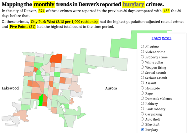
Denver crime trends map
The crimes trends map shows the change in crime counts and rates on a monthly and year-to-date basis.

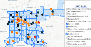
The Denver-city recent crime map
The recent crimes map shows where crimes across the city were reported in the last two or so months, and shows which addresses across the city have logged the most reported crimes.

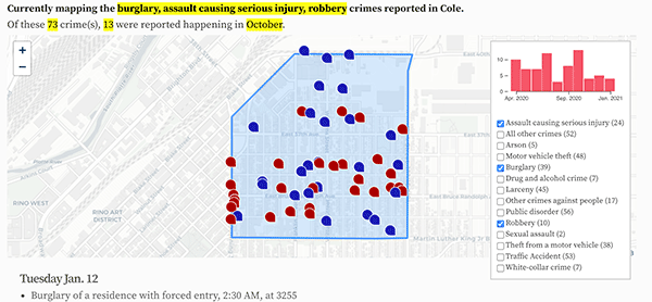
All city crime maps
Choose from neighborhood and crime-specific crime maps.
